2. Oil Pollution
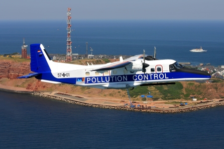
Airborne Maritime Oil Spill Surveillance

Source: Central Command for Maritime Emergencies, Cuxhaven, Germany
Many coastal states worldwide operate maritime surveillance aircraft to monitor their coastal zones. Among other official duties, their task is to prevent the coastal waters from illicit and accidental oil pollution. Taking the North Sea as an example, the estimated discharge of oil in the years from 1980 to 1990 was up to 50.000 tons per year. At that time, newspapers reported almost daily on oil spills that killed seabirds and polluted the beaches. Since then the amount of oil pollution at sea has decreased by more than 50%. This favourable trend has its roots in putting aircraft into operation that are equipped with instruments to detect and quantify oil at sea.
The performance of oil spill instruments is manyfold. Installed aboard aircraft, they can detect spills over distances of more than 20 km. Following spill detection, the type and quantity of substances on the sea surface is analysed at flight altitudes of 300 m, typically. This is the challenge of remote sensing!
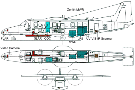
Spill detection over 20 km distance is done with radar, which is a unique long-range sensor. The analysis of the sea surface at close distance is achieved during overflight of spills with various downward-looking instruments which use the near ultraviolet (UV), visible (VIS), infrared (IR) and microwave (MW) spectral range. Examples of these near-range sensors are the multispectral scanner for the UV, VIS and/or IR, the microwave radiometer, and the laser fluorosensor.
Active and passive operation is another distinctive feature of remote sensing instruments. Passive sensors detect signals which are naturally available, e.g., sunlight reflected or thermal radiation emitted from a target. Examples are the multispectral scanner and the microwave radiometer. Active sensors provide their own source of radiation for target illumination and signal detection. Examples are the radar and the laserfluorosensor. Photocameras and video cameras which are also used to keep records of the scene on the ground can be either passive or active, depending on daylight or flashlight use for object illumination.

Source: Dornier Aerospace, Friedrichshafen, Germany, with modifications.
Until the late 1980ies, oil spill analysis was done with visual inspection. Indeed, an experienced oil spill expert has learned to distinguish thick oil layers and thin films on the water surface due to their specific colour appearance. However, quantitative information on the oil film thickness and on the type of oil can be obtained with remote sensing instruments only. Follow the links below to find out more about the instruments used in airborne oil spill monitoring:
