Why use remote sensing for coral-reef research?
Already since the late 1960's, space photography has been used to detect all kinds of features on Earth. Since the first Landsat data became available in the mid 1970's, research has explored possible applications of remote sensing in coral-reef science and management. Since then, many studies have shown the usefulness of remote sensing for providing baseline information on coral reefs.
The availability of accurate information on coral reefs and the human exploitation of these natural resources is crucial for any future management strategy aimed to protect the coral reefs.
Getting all this information through remote sensing gives insight in the natural variability and long-term trends of the coral reefs. Against this background, managers can interpret the impact of new natural disturbances of human activities.
The following data on coral reefs can be obtained through remote sensing:
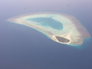
- Localization of a coral reef.
However, the composition of the bottom of the sea is needed to find out where coral reefs can be located.
Check out the bathymetric mapping page. - The kind of reef and its form. If this information is available, scientists can try to find out which processes are active around the reef.
Discover what geomorphological zonation means. - Information about the reef communities (corals) and the surrounding area (seagrasses, bare substrate…).
Have a look at what is a bottom-type classification. - Changes over time in the above elements.
Remote sensing may be applied to track the evolution of human activities which negatively interfere with the
coral-reef environment, for example, the expansion of coastal urban centres.
See by yourself how useful can change detection be.
Can remote sensing always be used to map coral reefs?
Unfortunately, there are some restrictions to be able to study coral reefs through remote sensing.
Only shallow water corals will have a reflection and be thus visible on a satellite image. From the point where all wavelengths are absorbed by the water (at a certain depth), no corals can be detected anymore.
The water may not be too turbid, which will result in a very unsharp image.
The third condition is that there may not be cloud cover, which is often a problem in the tropical regions where corals grow.
