Bathymetric mapping - How deep is the sea?
The relief of the sea
Mountains, valleys and plains do not only occur on land! The bottom of the sea has plenty of them, too. Large mountains, called ridges, can be found in the deep ocean, whereas smaller relief features are found closer to the coast.
And because depth is a limiting factor for the occurence of coral reefs, it is interesting to know what the bottoms near the coast look like.
Measuring while snorkeling?

Fortunately not! Images taken from space can provide this information quite easily.
To be able to interpret depth out of these satellite images, some basic principles need to be explained.
A fundamental principle
When light passes through water, it becomes attenuated by interaction with the water column. Different wavelengths of light (blue, green, red) will penetrate water to a varying degree:
- red light is attenuated rapidly and does not penetrate further than about 5 m in clear water.
- blue light penetrates much further and in clear water, the seabed can reflect enough light to be detected by a satellite sensor even when the depth of water approaches 30 m!
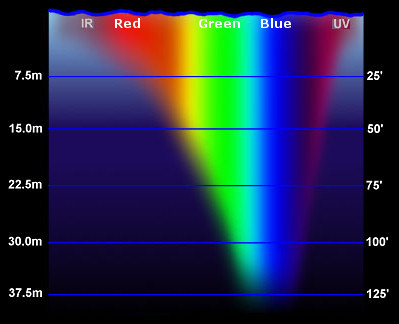
Source: Tom Morris, Fullerton College.
What the satellite's sensor perceives depends on the depth
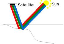
In shallow areas:
Blue, green and red light (the components of white light from the sun)
penetrate through the water column and all three are reflected by the sea bottom.
The sensor in the satellite thus receives information from it in its blue, green and red band.
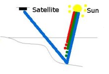
In profound water:
Blue, green and red light penetrate through the water column.
At certain depth, red light gets attenuated, so does the green light at greater depth.
Only blue light is reflected by the bottom and received by the sensor.
Both green and red bands in the sensor don't receive any information which gives a black image as result.
Result
Analyzing the information captured by the sensor gives you a detailed description of the sea bottom close to the coast. A map which - after transformation in a GIS - displays depth is called a bathymetric map.
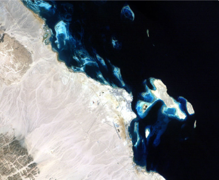
Source: Vanderstraeten, 2007.
