Remote Sensing of Cultural Heritage Sites
Dresden and the Elbe Valley in Germany (1/2)
The Dresden Elbe Valley in Germany is an 18th and 19th century cultural landscape that stretches some 18 km along the
Elbe River through the city of Dresden from Übigau Palace and Ostragehege fields in the north-west to the Pillnitz Palace
and the Elbe River Island in the south-east. It features low meadows and vineyards, and is crowned by the Pillnitz Palace
and the centre of Dresden with its numerous monuments and parks from the 16th to 20th centuries.
The landscape is also characterized by 19th and 20th century suburban villas and gardens and some old villages
that have retained their historic structure and elements from the industrial revolution, notably the 147 m Blue Wonder steel bridge
(1891-93), the single-rail suspension cable railway (1898-1901), and the funicular (1894-95).
This valley has been the crossroads in Europe, in culture, science and technology and is also an outstanding example of
land use, representing an exceptional development of a major Central-European city.
The Dresden Elbe Valley was inscribed in 2004 to the UNESCO World Heritage List. However, in June 2009, during the 33rd session
of the World Heritage Committee this site was removed from the list due to the building of a four-lane bridge in the heart of the
cultural landscape which meant that the property failed to keep its "outstanding universal value" as inscribed.
The Committee said that Germany could present a new nomination relating to Dresden in the future. In doing so,
the Committee recognized that parts of the site might be considered to be of outstanding universal value,
but that it would have to be presented under different criteria and boundaries.
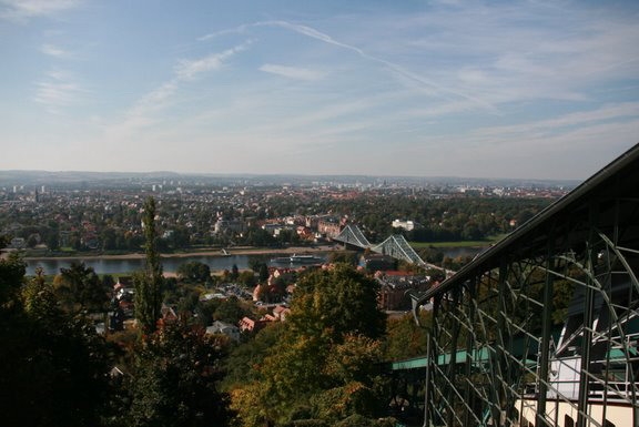
Photo: Liliana Manns
Contribution of Remote Sensing
Due to its location on the banks of the Elbe River the city of Dresden is often endangered by floods. Large areas are kept free of buildings to provide a floodplain.
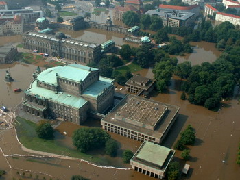
Photo: Feuerwehr Dresden
In August 2002 this World Heritage site was affected by heavy floods of the River Elbe and its tributaries Weißeritz and Lockwitzbach.
Satellite data is a good tool for flood monitoring because it gives a precise and quick overview of flooded areas.
This information is useful for authorities in order that they can take further action.
The analysis of satellite images helps to evaluate and declare regions at risk and to develop protection plans for the future.
By combining data about the flooded areas and land use information, for example industrial areas, settlements, pastures, agriculture, woods etc, it is possible to evaluate the economic loss and create more accurate risk plans.
A multitemporal evaluation of the flood events can help to understand and analyze the spatial and temporal dynamic of the event. This is done by using a set of successive images of different days of the flood event. This type of evaluation allows us to better rate damages (e.g. contamination of soils) as well as consequential costs (e.g. production loss, caused by impassable access roads).
