Introduction
Phenology can be defined as the study of the timing of recurring natural phenomena.
With regard to vegetation, phenology is the study of the timing of:
- In annual plants, the sequence of events from germination to death.
- In deciduous perennial plants, the point when the new buds burst to when the leaves fall.
- And lastly the study of the annual cycle of evergreen species.
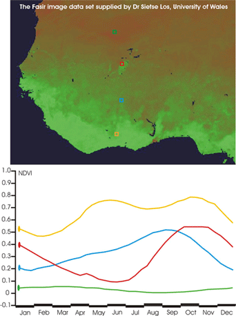
The video clip on this page shows 36 Normalized Difference Vegetation Index (NVDI) (This is just a way to process remote sensing data to tell us if there is vegetation where we are looking) images for 1982 derived from the Fasir time series. In these images, green represents an NDVI value of 1.0 (lots of vegetation) and brown represents a value of 0.0 (little vegetation). Below the images are the NDVI profiles for the four locations marked on the clip with the months of the year of the displayed on the x axis watch the film and see how they correspond.
These four locations are:
Kotobi, Ivory Coast, 6° 44' 00.3" N, 4° 14' 42.5"W
Bobo Dioulasso, Burkina Faso, 10° 58' 14.2"N, 4° 10' 40.5"W
Toguere Koumbe, Mali, 14° 53' 20.0"N, 4° 34' 39.1"W
Hodh och Chargui, Mauritania, 18° 26' 33' 7"N, 5° 07' 47.1"W
Now watch on the animated time series on the right. Think about and make a note of your answers to the questions below.
(You might need to click on the timeseries to make the animation play, it depends on your browser.)
- From the profiles shown what can you tell about the vegetation in the four locations?
- Which is a desert area?
- Which is a moist forest region?
- Which is a river delta region?
When you are done you can check your answers by revealing them on the right.
Note:
Rainfall is highest in the south and decreases as one goes north. Rain falls most of the year in the south but in the north it is limited to a wet season from July - August.
Click here to reveal the answers ↓ ↑
Hodh och Chargui is a desert region. The NDVI values are very close to 0.0 indicating that there is negligible green vegetation in the area. The NDVI profile stays at these values throughout the year, showing that, at least in 1982, there is never a period with significant green vegetation.
Kotobi is a moist forest region; close to being rainforest. The profile has high NDVI values throughout most of the year, with a dip down to about 0.5 for approximately three months at the beginning of the year. With values of 0.5 in NDVI the area would still have been predominantly green throughout most or all of a year.
Now which of the other two is a river delta region?
Toguere Koumbe is north of Bobo Dioulasso, and the area around it is drier, because the NDVI values around it are lower throughout most of the year. This means that Toguere Koumbe probably gets less rain than Bobo Dioulasso. The rain that it gets is concentrated in July-August, whilst the rainfall in Bobo Dioulasso covers a longer period, possibly from May to September. The peak green in Bobo Dioulasso occurs during the end of the wet season, whilst the peak at Toguere Koumbe is after the rains have stopped. The peak also remains at a high value for a long period.
If you look at an atlas you will see that Toguere Koumbe is in the swampy flood plain of the Niger River where it disgorges out of hilly country. The rains swell the Niger River, which carries the water down to this flood plain, where it forms a vast swampy area that then greens up. This is why the peak of the NDVI is delayed after the rains and why it stays at high NDVI values for a long period. If you look carefully you can see the green spot on the image which shows you the extent of this delta.
Fasir phenology timeseries.
