3. Resolution
Spectral resolution
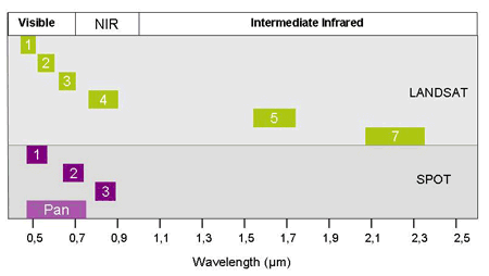
Spectral resolution is defined through the number of spectral bands and their width. Their purpose is to capture the differences in the reflection characteristics of different surfaces.
While the human eye only recognizes the visible spectrum of light, a satellite can, depending on the type, depict radiation differently in many spectral areas. The majority of passive earth observation satellites have between three and eight bands and are therefore called multispectral as for example the American LANDSAT and the French SPOT.
The higher the spectral resolution, the narrower is the wavelength range for a specific band, and therefore, the more bands there are. With a higher spectral resolution single objects can be perceived better and spectrally distinguished.
Visible light: In the area of visible light passive satellite sensors are as sensitive as the human eye. Satellites "see" about the same as a person would see when looking at the earth from an altitude of about 1,000 km. The satellites only capture what is being lit by the sun.
Infrared sensors measure radiation in the near, middle, and far (thermal) infrared. The data can be converted to temperatures of the land and ocean surface in the cloud-free conditions, and to the temperature at the top of clouds during overcast.
Panchromatic sensors detect broadband light in the entire visible range, and signal intensities are displayed as grey levels, i.e., black and white imagery.

