4. Mass Tourism
Case study Tenerife (3/8)
Location and Climate
The location and climate of Tenerife makes it popular as a holiday island and attracts millions of tourists every year. Get an overview of the location and climate of the island.
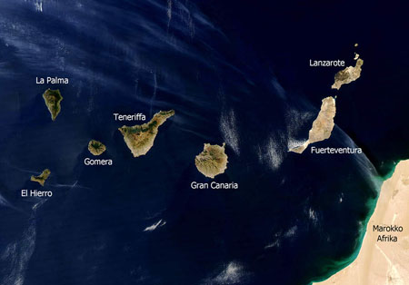
Location. Tenerife belongs administratively to Spain. With a size of 2,052 km² it is the largest of the Canary Islands. It is situated about 1,300 km off the Spanish mainland.
Whilst the geological evolution of the island is still debated, its volcanic origin is beyond dispute. The visible evidence is the Pico del Teide, 3.718 m above sea level which makes it the highest mountain of Spain.
Source: Wikipedia
Climate. The Canary Islands are located in the subtropical zone. Their climate is affected by westerly winds, Atlantic low pressure regions, trade winds and the proximity to the African continent. The climate of the islands is in general very moderate and balanced in every season, the average temperature is between 17-18°C in winter and 24-25°C in summer.
During the day the maritime air masses soar along the northern slopes of the Teide massif and form clouds at about 1,000 - 1,500 m altitude. These condense to drizzle when they come in contact with local laurel and pine forests. This gives crucial advantages to agriculture on the northern side of the island in the rather dry summer months.
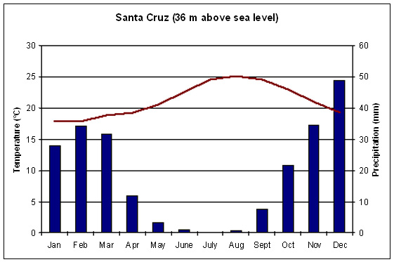
Own illustration, Data: AEMET
Tasks: 1. Describe the climatic conditions of Tenerife
with the aid of the climate chart.
2. Name possible advantages but also problems related to tourism
that can occur in such a climate.
3. Incorporate the satellite images into your thoughts.
a) What could the yellow stripes respectively the areas off the Moroccan coast mean?
b) How might this influence the climatic conditions of the Canary Islands?
