4. Invasieve soorten in de oceaan
Teledetectie van mariene invasieve soorten
Kunnen we invasieve mariene soorten vanuit de ruimte zien?
Het antwoord is: sommige wel, afhankelijk van hun aard en omvang.
Beelden die afkomstig zijn van teledetectiesystemen geven doorgaans een gemiddelde weergave van de informatie die ze detecteren over tientallen of zelfs honderden vierkante meters. Sommige commerciële satellieten bieden een ruimtelijke resolutie van iets minder dan 3 m, zoals SPOT (2,5 m), IKONOS (1 m) of Quickbird (0,61 m). Luchtfotografie kan in theorie beelden leveren met een ruimtelijke resolutie van slechts enkele centimeters.
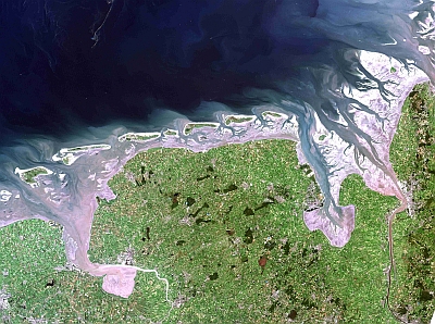
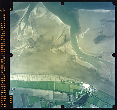
Bekijk de twee afbeeldingen van de Noordzee hieronder. De ene is een satellietfoto met een gemiddelde resolutie van 30 m, de andere is een luchtfoto met een ruimtelijke resolutie van &60; 1 m. Welke soorten kunnen volgens u op basis van deze foto's worden onderscheiden? (Let op: de resolutie van de foto's is verlaagd om de laadtijd te minimaliseren).

Landsat 7 ETM-beeld van de Duitse Noordzeekust en de Waddenzee.
Bron: Eurimage 2002, verstrekt door het Nationaal Park Waddenzee van Nedersaksen

Luchtfoto van de Dornumer Nacken, Duitse Noordzee, gemaakt op 12-09-2008.
Bron: Nationaal Park Waddenzee van Nedersaksen
De voordelen van de twee platforms (satelliet en vliegtuig) worden meer in detail uitgelegd in het hoofdstuk over Detectie en monitoring van mariene vervuiling met behulp van teledetectietechnieken.
Het opsporen van invasieve mariene soorten in optische beelden is over het algemeen vrij ingewikkeld en vereist veel grondonderzoek, d.w.z. veldwerk om te controleren of wat we op het beeld zien ook echt is wat we denken dat het is. Afzonderlijke soorten kunnen mogelijk worden opgespoord op luchtfoto's met een zeer hoge ruimtelijke resolutie. Dit zou echter de omvang van het onderzochte gebied aanzienlijk verkleinen.
Hoewel het bijna onmogelijk of in ieder geval niet kosteneffectief is om invasieve mariene soorten te monitoren met behulp van eledetectie, zijn er voorbeelden van toepassingen van teledetectie die indirect kunnen worden gebruikt.
(1) De routes van invasieve soorten in de oceanen worden vaak bepaald door oceaanstromingen, die op hun beurt kunnen worden gevolgd met behulp van satellietbeelden.
(2) Hoewel het niet mogelijk is om verschillende soorten zeeplanten te onderscheiden op satellietbeelden, kunnen veel plantensoorten worden waargenomen door de kleur van de oceaan te detecteren.


