3. Harmful Algal Blooms
How remote sensing can help to detect and follow algal blooms
Monitoring and prediction of algal blooms in the marine environment has become more and more important in the recent years as they are increasingly perceived as a potential threat. Especially in the field of natural resource management and in the public health sector, reliable tools to detect and monitor Harmful Algal Bloom (HAB) events are needed so that mitigation actions can be effectively taken.
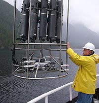
Measurements carried out from a research vessel, so called in-situ (on the spot) data acquisition, is very useful for determining different algal species. However, when it comes to questions concerning the area and movement of an algal bloom, this method is not cost-effective.
How does it work?
The main advantages of using remote sensing are a high spatial and temporal resolution, meaning that large areas of algal blooms can be studied and that their movement can be followed by looking at images captured at different times.
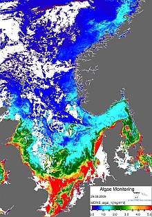
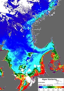
By comparing the two images below you can see how the chlorophyll concentration in the sea can change within just one week. The pseudo-coloured images show the relative chlorophyll content of the sea from blue and green (low) to red and yellow (high).
Source: NERSC / ESA
Remote sensing of Algal Blooms is mainly based on measurements of ocean colour. Optical remote sensing of algal blooms takes advantage of the fact that water is strongly affected by algal pigments.
In the open ocean, variations of the water colour are solely determined by phytoplankton.
In near shore and coastal areas , the optical properties of the sea water are much more complex. Suspended sediments and dissolved organic compounds are also responsible for ocean colour. Riverine inputs and regional wind and ocean current patterns cause turbidity in coastal waters which in turn change the optical properties of the water.
What colour does the ocean have?
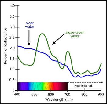
Your answer is probably blue and you are quite right with this - for most of the world's oceans. However, one of the most important things that influence the colour of the ocean are phytoplankton which contain chlorophyll.
The equation is fairly simple:
the less phytoplankton, the bluer it is.
What do satellites measure?
Satellite sensors detect the light reflected from the sea surface in different wavelengths. Chlorophyll concentrations can then be derived from satellite data by calculating the blue/green ratio of the ocean colour. The more blue colour is absorbed, the more green colour is reflected, indicating a higher concentration of phytoplankton in the sea water and the other way around.
In coastal areas larger proportions of inorganic matter are suspended and dissolved in the sea water. Here, another method is used that calculates chlorophyll using the red/near infrared ratio.
Remote sensing of algal blooms: requirements and limitation
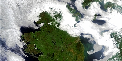
Optical remote sensing can provide valuable (and beautiful!) images of algal blooms when a certain set of criteria is met. These are
- No cloud cover
- The bloom is near to the surface
- The bloom causes perceptible change in ocean colour
Due to abundant cloud cover over the sea the image below, for example, is not very helpful in terms of detecting marine algae.
Question:
From what you have learned about the nature of algal blooms and the methods to look at them from space, would you think that from a satellite image it is possible to determine whether an algal species is harmful or not?
Learn more:
- Eutrophication
- Eutrophication in the European Seas
- Harmful Algae
- MERIS Ocean colour sensor
- SeaWiFS Ocean colour sensor
- SEOS tutorial on Ocean Colour in the coastal zone
- List of current Ocean-Colour Sensors
(International Ocean Colour Coordinating Group, IOCCG)
