Eigen illustratie, Gegevens: Soja, Kanai 2007
Objectives:
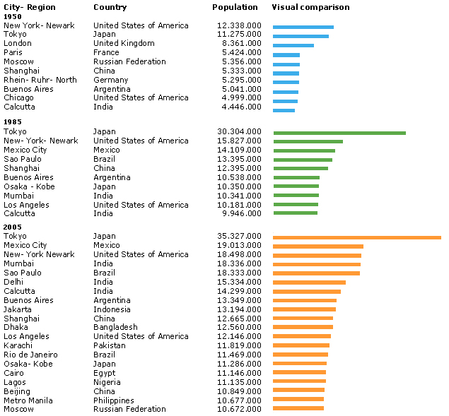
In this worksheet the development and the increase of mega cities worldwide is depicted. Besides the analysis of the location of the biggest cities worldwide, the causes behind this developments are in focus.
Didactical comment:
- This worksheet should visualise the increase of mega cities worldwide over time.
- Additionally, the students can analyse with the help of an atlas the location of the growing mega cities. By that, the students can discover that the most increase in city number and size is located in the Third World.
- This analysis is followed by a transfer task, where the students should think of reasons for this mega cities growth and why especially cities in the developing world are increasing this rapidly.
Solution of Worksheet 'Increase of Mega Cities'
1. Mark the development of mega cities on the world map above in three different colours:
Year 1950 - blue marks, Year 1985 - green marks, Year 2005 - orange marks
For the solution see figure above right: world map with mega cities
2. What can you notice in respect to the distribution of mega cities on the world map?
Especially in recent years mega cities in developing countries are increasing in size and number. In the industrial countries there are comparativly less mega cities. The largest cities on earth are now Tokyo, Mexico City and New York.
3. Estimate possible consequences of this rapid urbanisation.
In the developing world, the rural-urban-migration is one of the main reasons for increasing urbanisation. People are moving from rural to urban areas because of so called push- and pull-factors, like for example the dream of a better life, or the hope for more employment possibilities in the cities. For the industrial countries, New York is since centuries the destination of thousands of migrants. Lot's of them migrate not only to find work and earn money, but also because they hope for succes and fortune.