Crop Yield Estimation Supplement
Mars Crop Yield Forecasting System (MYCFS)
The Mars Crop Yield Forecasting System employed by the MARS (Monitoring Agriculture with Remote Sensing) STAT sector of the Agriculture and Fisheries Unit of the Joint Research Centre (JRC) is a system that combines remote sensing data with other forms of data and information. The system consists of independent components that are combined to form the system. The main components include the processing of meteorological data, a model that simulates crop growth, the processing of remotely sensed data and the calculation of indices, and the production of indicators based on a time series of data produced by the previous components.
The model simulating crop growth includes parameters such as soil crop calendars, crop practices and crop parameters (which are more or less constant for each crop and originate from the crop's knowledge base) and soil parameters. The remote sensing data come in the form of low and medium resolution from SPOT-Vegetation/NOAA-AVHRR and MERIS/MODIS, with a 1 kilometre and 300-500 metre resolution respectively. Those satellite systems have the advantage of a frequent revisit period, which means that the time between two successive passes over the same area is very small. SPOT-Vegetation can cover almost the entire Earth in one day, as it can be seen by the image on the right. This allows to select the scenes with the least cloud cover over a period of a few days and create a global mosaic of images with minimal or even no cloud cover.
The products of the process are databases and mapped representations of the agricultural quality indicators for the season. These include extreme temperatures that were observed at some point in the growth season, simulations of the produced biomass and yield, soil moisture, development stage of the crop in comparison to the expected stage it should have reached at a particular moment.
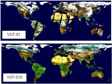
Source: Joint Research Centre
The system is producing meteorological and agro-meteorological maps every 10 days, which are analysed and included in bulletins, published monthly. Currently the system is addressing the countries in the Mediterranean basin, the CIS countries, Eastern Africa and South America. The monitoring programme is providing early risk warning when abnormal weather conditions are detected, which allows for a prompt response in the form of corrected farming practices.
For more information visit the Mars Crop Yield Forecasting System methodology website, of the Agriculture and Fisheries Unit of the JRC.
