1. Space and its Dimensions
The History of 3D
The very first known maps presenting objects and phenomenon using cartographic symbols date from 2.500 years B.C. One of these maps is the famous map of Mesopotamia.
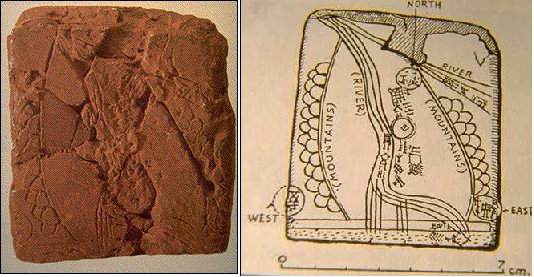
Source: Commission on Mountain Cartography, 2006
This map is a combination of two different views:
- The majority content is mapped in an orthographic way.
- The mountains are presented in a perspective way.
Following the development of cartographic design throughout the Greek and Roman era, we realise that cartographers have always wanted to represent the relief as realistic as possible, using mostly perspective drawings of hills and mountains.
After the stagnation of development in the Middle Ages, a renaissance of cartography during the 15th century brought about a continuation of perspective presentations. We had to wait until the 18th century before the first relief representations showing morphological forms in an orthographic way could be introduced. Have a look…

Hatching Source: Commission on Mountain Cartography, 2006 |
The first method called 'hatching' indeed enabled some basic
measurement tasks, like determination of slope, but a big disadvantage of the method was extreme
graphical overloading.
|
| In the late 19th century, contours became the most
common way of relief presentation at all large scale maps, since this was the only method that enabled
full map measurements and exact definition of every point's height on the map. |
Contour lines Source: Commission on Mountain Cartography, 2006 |
Consequently, orthographic maps became predominant in the 20th century. A minority of perspective maps was still produced but mainly for touristic purposes.
To summarise, we can see that orthographic maps dominated our history only during the last 200 years, while perspective type maps which are more adequate to normal people's viewing have been used for thousands of years.
Article: Analysis of user's response on 3D cartographic presentations by Dušan Petrovič and Polona Mašera.
