Supplement 5.2: More about Sea Ice
Types of ice
Packs, floe, fast...or just drift?
Fast ice
This is sea ice that has frozen along coasts, it is known as fast ice (from fastened to the land or land-fast). It stays attached to the coast and does not move with the wind or currents.
This term is also used for ice attached to the sea floor over shallow parts of the continental shelf. This may also be referred to as anchor ice.
Drift ice
Any sea ice that is not fast ice is known as drift ice.
Pack ice
When packed together in large masses, drift ice is called pack ice.
The Arctic and Antarctic ice packs act as sources and sinks of large amounts of water as they advance and retreat during the year.
The image on the right is a photograph taken from the International Space Station showing drift ice in the Labrador Sea. The ice is probably breaking away from pack ice along the coast of Newfoundland during the spring melt.
Ice floes
Any relatively flat piece of ice 20 m or more across is known as an ice floe. An ice floe wider than 10 km in any direction can be referred to as an ice field.

Source: Amanda Grobe and Hannes Grobe, Alfred Wegener Institute for Polar and Marine Research, Bremerhaven, Germany.
Satellite view of ice floes
The MODIS image on the right shows ice floes in the Labrador Sea off the Canadian coast.
Just offshore, the sea ice appears as a soft bluish-white; the criss-crossing lines are stress fractures caused by the ice breaking up into large chunks.
The white swirls visible farther out to sea are comprised of crushed ice where the Labrador icepack has been ground up into finer floes, comprised of chunks a few metres across.
The wind and water currents organize these floes into bands that get carried out to sea. These ice floes can be hazardous to maritime vessels traveling along the Labrador Coast.
How thick does the ice grow?
First year ice usually reaches a thickness of 1-2 metres. Multiyear ice can go through the growth-melt cycle many times, with the thickness increasing from year to year.
However, as ice acts as an insulating layer for the ocean, as ice gets thicker, less heat is lost to the atmosphere from the ocean, and the rate of ice growth slows.
Sea ice eventually reaches what scientists call a state of thermodynamic equilibrium. The ice becomes so thick that no heat from the ocean can be conducted through the ice, and ice stops growing. It may take several years of growth and melt for ice to reach an equilibrium thickness.
Note: the transfer of heat from the water to the atmosphere is only part of the picture. Winds and currents can move the ice around, forming, for example, ridges. Heat can also be moved away from the ice by the same processes.
In the Arctic, the thickness of sea ice required to achive thermodynamic equilibrium is approximately 3 metres. However, dynamics (winds, currents...) can yield sea ice thicknesses of 10 metres or more. The equilibrium thickness of sea ice in the Antarctic is much lower, typically ranging from 1 to 2 metres.
Snow cover
Sea ice is usually covered with snow, which insulates the ice and delays melting in the summer. Except during a melt season, the snow is usually dry, wind-blown, and hard-packed. Snow ridges, just like small sand dunes, can be formed when the wind blows in a consistent direction. The ridges are formed parallel to predominant the wind direction.
Other features that form on the surface of sea ice are frost flowers, crystals of ice deposited on the sea ice when water vapour bypasses the liquid phase and becomes a solid.
Snow modifies the electromagnetic radiation signal detected by satellites.
Frost flowers roughen the surface and so also dramatically alter its electromagnetic signal.
Open water?
Leads and Polynyas
Areas of open water in sea ice are known as leads or polynyas, depending on their shape. Leads are narrow, linear features, while polynyas are generally more uniform in shape and larger in size.
Leads form because of the motion of the ice, while polynyas form from either upwelling warm water or persistent winds.
During winter, open water remains in leads for only a short time before it begins to refreeze, while polynyas usually remain unfrozen for long periods of time.
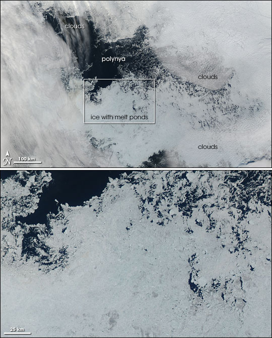
Polynya far north (image right)
In August 2006, a polynya developed north of Alaska, in the Beaufort Sea - an area where satellites have not typically detected open water.
The Beaufort Sea polynya of 2006 formed in mid-August and continued to grow through early September. By September 11, 2006, the area of open water had grown to roughly the size of the state of Indiana - about 100,000 square kilometers (38,000 square miles).
Melt ponds
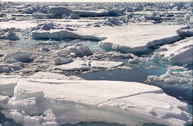
When the snow on top of sea ice melts in the summer, the meltwater can accumulate in depressions on the sea ice surface called melt ponds. These ponds grow as they heat up preferentially. Remember water absorbs more energy from sunlight than the surrounding ice which reflects it.
The fresh water in melt ponds appears blue because light reflects and scatters off the sea ice surface from the bottoms and sides of the melt pond. If a pond melts through the entire thickness of the ice, the pond’s colour turns dark, like the ocean.

Source: Image Science and Analysis Laboratory, NASA Johnson Space Center.

Source: NASA

The top image shows the polynya and its immediate surroundings. In this image, the polynya appears as a sprawling black shape in the sea ice.
The bottom image is a close-up view of the area immediately south of the polynya. In this image, the sea ice appears blue and more loosely packed than the ice farther north. The bluish color of the ice is the result of liquid water from melting on the surface of the sea ice.
The high-resolution image provided above is at MODIS’ full spatial resolution (level of detail) of 250 meters per pixel.
Source: NASA
Melt ponds also change the electromagnetic radiation signal detected by satellites.

