5. Urban Planning
Limitations of remote sensing in urban environments
The application of remote sensing to specific problems has proceeded more rapidly in agriculture, geology, cartography, meteorology, and natural resource management than in urban analysis and research. Therefore the growing emphasis is on identifying new urban remote sensing applications for policy and management.
One factor that must be considered in thinking about urban applications of remote sensing is that there are often better sources of the same information that can be obtained more economically, particularly for cities in developed countries. This is not always the case in developing countries, however. Since urban settlement in developing countries is often informal, municipal records, when available, usually cannot keep pace with changes in the extent of settlements. Mapping the advancing line of settlement with remote sensing is thus more useful in these settings.
Source: Satellite Imaging Corporation
However, remote sensing may be a suboptimal tool for obtaining information on the built environment if more detailed information is already available from regulatory, governmental or commercial sources. It is also unlikely that optical and microwave sensors will be able to obtain population counts that are as accurate as those currently provided by census data. Nor can imagery measure the economic, policy, or social causes of observed spatial phenomena, although it can help quantify their consequences and extent.
If remote sensing is to improve our understanding of urban environments and our capacity to manage them in the future, then urban applications of remote sensing must be developed which take advantage of the unique characteristics of the data. These include (1) the self-consistent and synoptic nature of the data; (2) its capacity for routine, periodic, and unobtrusive updating and comparison; (3) its capacity for the description, classification, and measurement of critical physical properties that would be prohibitively expensive or impossible to obtain in situ; and (4) its synoptic spatial coverage
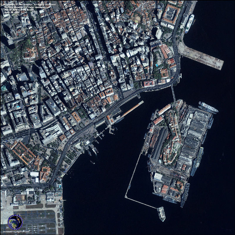
How can we recognise urban areas?
Urban areas are generally recognized in remotely sensed imagery by their geometric and textural characteristics. Spectral characteristics of urban landcover are less diagnostic than those of the rural periphery and unpopulated areas such as deserts and forests.
The Landsat TM and ETM+ sensors clearly resolve spectral differences between developed urban land cover and undeveloped non-anthropogenic land covers. The correspondence between lighted area and urban land use can be quantified using Landsat imagery. Satellite image of Philadelphia, Pennsylvania.
Urban areas generally have higher solar radiation absorption and a greater thermal capacity and conductivity because of being covered with buildings, roads and other impervious surfaces. Urban areas tend to experience a relatively higher temperature compared to the surrounding rural areas. Higher urban temperatures generally result in higher ozone levels due to an increased ground-level ozone production. Higher urban temperatures also mean increased energy use, mostly due to a greater demand for air conditioning. As power plants burn more fossil fuels, they drive up both pollution level and energy costs. To better understand the impact of urban development on land surface temperatures, we can observe the thermal signature of each land cover type and overlay a land surface temperature image with a land use and land cover map in the same year.

Source: Satellite Imaging Corporation
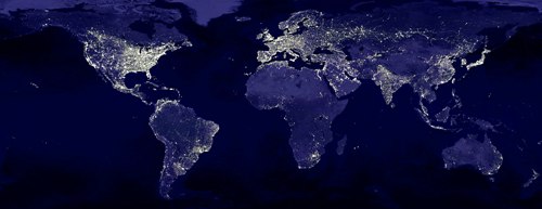
An easy method to detect urban areas and boundaries is using satellite data: night-time lights is the only globally consistent source, though it is not without problems.
Source: NASA
