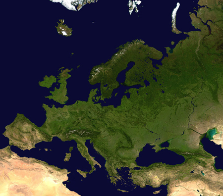
Satellite image mosaic of Europe, viewed by SPOT Vegetation in 2002.
Source: Beckel 2007
Source: Beckel 2007
Tasks:
- Describe the satellite image mosaic of Europe. What different patterns and surface structures (regional landscapes) can you identify? You may use additional references such as topographic, geological, soil, or regional planning maps.
- The main colours in the image (green, yellow, brown) represent changes in land cover. How are they linked with land cover types like forests, pastures etc. and where can you identify large settlement areas?
- A mosaic is composed of a number of images taken from various satellites. In which season (spring, summer, fall, winter) do you think the images were taken? Explain your decision.
- Take a transparency film and cover the image with it; use paper clips to secure the transparency. Label distinctive points and trace the coastline.
a. Draw the country borders of the European countries with the help of an atlas. Discuss in class why some boundaries follow natural surface features and others do not.
b. Delineate important regional landscapes and label them with the help of an atlas.
