Crossing the Atlantic against the Currents!
Imagine you are in Brest, France, and you set sail to cross the Atlantic to Miami, Florida, on a small motorboat capable of travelling at 10 knots (5 m/s). That means that the boat’s speed would be 5 m/s if there was no current, but the real speed of the boat will be the sum of its speed relative to the current and the ocean current itself.
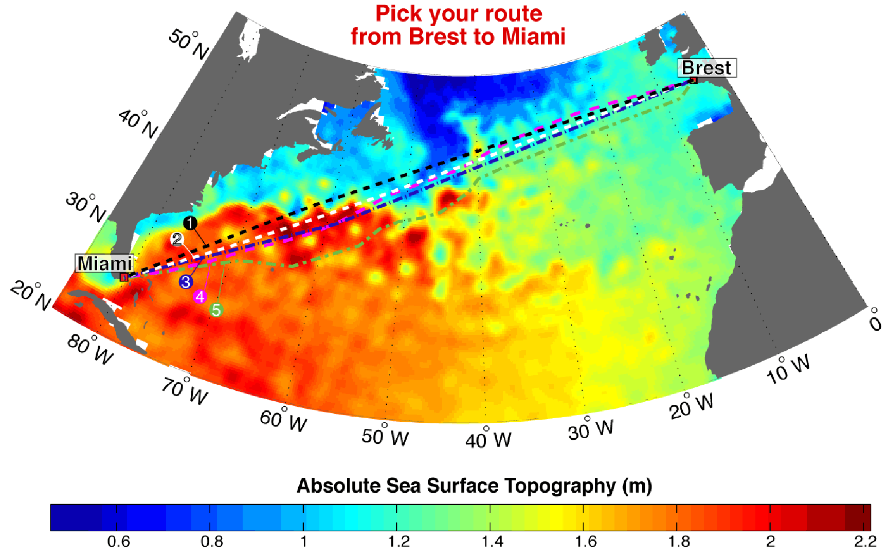
You have a map of absolute Sea Surface Topography taken from satellites (shown below, and taken from real satellite data), and you must choose one of five proposed routes (numbered 1 to 5, and also shown in different colours and linestyles on the map). Which one you think is the fastest one, that is the one with the shortest crossing time (which will also save you fuel!)?
Hint: you now know that currents and surface slopes are related, so try to use the currents to your advantage!
The table below gives the distance of the different routes. Take your pick, then check the results, in terms of crossing time in days, hours and minutes.
Score: 0.
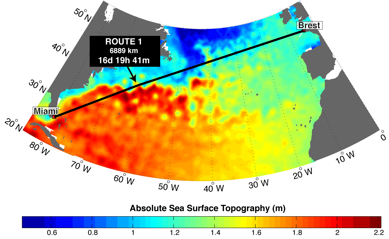
Not a good choice! This route turns out to be only marginally longer (in distance) than others, but much slower – it takes almost one day longer than the fastest crossing.
The reason is that over significant portions of this route you are running against the Gulf Stream – see for instance between 40° and 45°W, and even more so between 55° and 65°W where the ocean current is particularly strong (the sea surface slope is steep) and against the heading of the boat. (Click on image for a larger version.)
Score: 7.
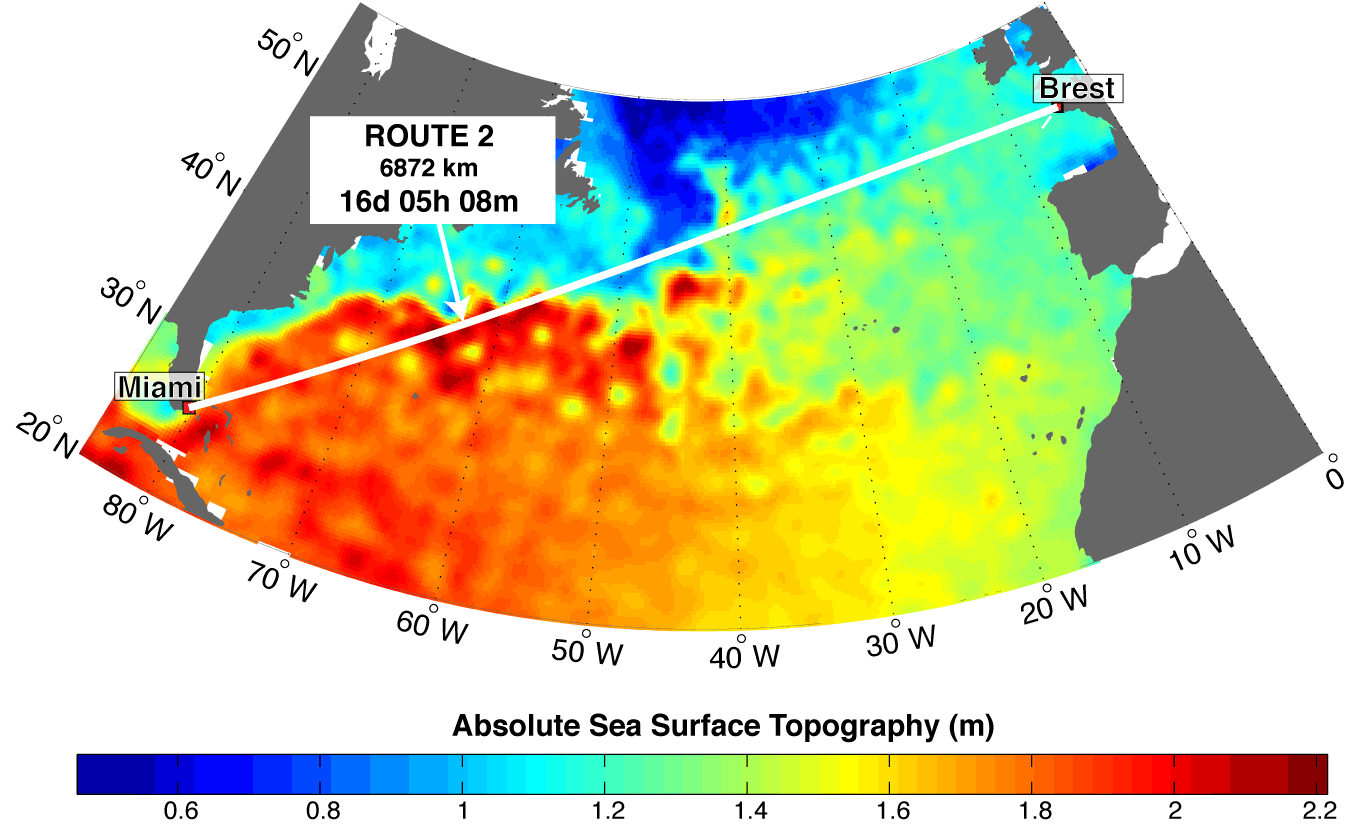
At 6872 km this is the shortest route in terms of distance, but not a particularly good choice in terms of crossing time. Already between 25°W and 45°W there are a few stretches where the current acts against us. And between 55°W and 65°W the boat sails very much against the main flow of the Gulf Stream. That is why it still takes more than 16 days to complete the crossing. (Click on image for a larger version.)
Score: 20.
Spatially, this route is very close to route 2 (and only a few km longer), but the slightly more southern course makes a BIG advantage in terms of crossing time! In fact this is the second fastest route after route 4. Most of the gain is between 55°W and 70°W, where we go via the southern side of some anticyclonic eddies (the positive ‘bumps’ in the sea surface) and there the current flows S-SW, therefore helping us a lot. In particular, compare this with route 1, which is exactly the same length, and see what a great difference it makes to have the currents working for you and not against you! (Click on image for a larger version.)
Score: 25.
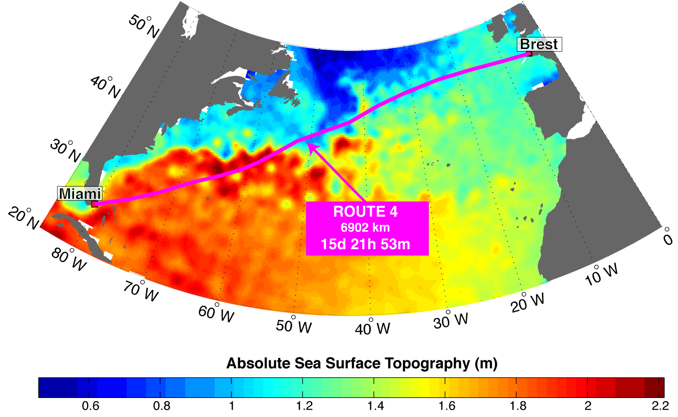
Would you believe it? This is the fastest route of the five, even if it is slightly longer than routes 1, 2 and 3. First, in the stretch between 20°W and 40°W we use to our advantage some small cyclonic eddies (the negative depressions you see in the sea topography maps), going via their northern side where the westward current helps us. Then again we get help by an anticyclonic eddy at 40°W, and a cyclonic one at 43°W. And then between 55°W and 70°W we have a big gain by going through the southern side of some intense anticyclonic eddies, as in route 3. As a result, our crossing time is 7 hours and 15 minutes less than the shortest route by distance (route 2). So, if you have chosen route 4, well done!! (Click on image for a larger version.)
Score: 20.
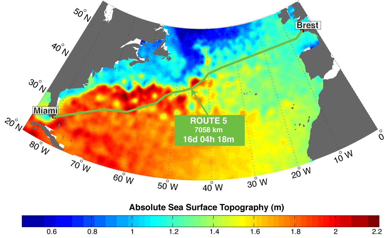
Not the fastest route, but not a bad choice either! This route is considerably longer (186 km longer than route 2), but it turns out to be faster (almost one hour less) than route 2, as it uses to its advantage some big eddies like the one at 44°W and the one at 63°W, circling them on the advantageous side. This particular, southernmost route might be a good option when other factors are taken into account – weather, for instance, or the need to avoid floating icebergs that are often a danger to navigation in the area southwest of Newfoundland (the big island off the Eastern coast of Canada). So this might turn out to be the ‘safest’ route after all, even if not the fastest. (Click on image for a larger version.)
Map of alternative routes. Click on the image for a larger version so you can see the current eddies.