Cartes de marées noires sur base de télédétection aérienne (en anglais)
Oil Spill Maps Based on Aerial Detection
Surveillance aircraft are operated by many agencies in Europe responsible for monitoring of coastal waters. Oil spills detected during flight missions are reported to international agencies which provide information on the amount of oil discharged at sea, including maps of the regional distribution of spills.
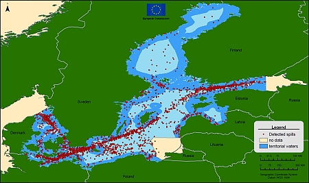
Oil spills in the Baltic Sea in the period 1998 to 2004

Source: Joint Research Centre, Ispra, Italy
From 1998 to 2004, a total of 2695 oil spills were detected in the Baltic Sea by the aerial surveillance of some of the members of the Helsinki Convention (Denmark, Estonia, Finland, Germany, Latvia, Poland and Sweden). Beware that the density of spills is closely related to the amount of surveillance which varies from one area to the other and that no data was available for Lithuania and Russia.
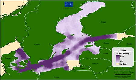
Oil spill density in the Baltic Sea in the period 1998 to 2004

Source: Joint Research Centre, Ispra, Italy
This map of oil spill density is derived from the spills detected in the Baltic Sea from 1998 to 2004 by the aerial surveillance of some of the members of the Helsinki Convention (Denmark, Estonia, Finland, Germany, Latvia, Poland and Sweden). Beware that the density of spills is closely related to the amount of surveillance which varies from one area to the other and that no data was available for Lithuania and Russia.
More information can be found on the following pages:
- Airborne Maritime Oil Spill Surveillance
- The Helsinki Convention / HELCOM
- The Bonn Agreement
- Website of the Joint Research Centre - European Commission: http://serac.jrc.it/midiv/
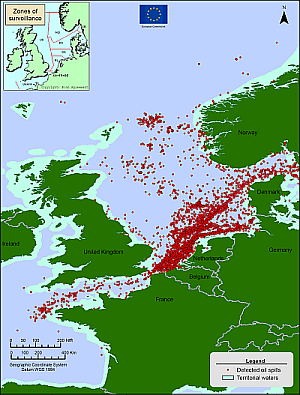
Oil spills in the North Sea in the period 1998 to 2004

Source: Joint Research Centre, Ispra, Italy
From 1998 to 2004, as represented in this map, a total of 4900 oil spills were detected in the North Sea by the aerial surveillance of the members of the Bonn Agreement (Belgium, Denmark, France, Germany, Netherlands, Norway, Sweden, United Kingdom). Note that the density of spills is closely related to the amount of surveillance which varies from one area to the other.
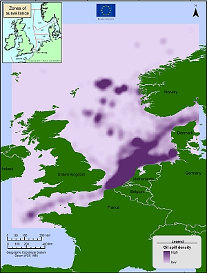
Oil spill density in the North Sea in the period 1998 to 2004

Source: Joint Research Centre, Ispra, Italy
This map of oil spill density is derived from the spills detected in the North Sea from 1998 to 2004 by the aerial surveillance of the members of the Bonn Agreement (Belgium, Denmark, France, Germany, Netherlands, Norway, Sweden, United Kingdom). Note that the density of spills is closely related to the amount of surveillance which varies from one area to the other.
