1. Lidar
What is a lidar?
In the introduction, we already encountered the term lidar as part of the LITE-Experiment in the Space Shuttle. A similar term which you might find more common is radar. Both are related to one another.
The abbreviations mean:
- Radio detection and ranging
- Light detection and ranging
Basically, radar and lidar are two very similar methods of active remote sensing that operate with electromagnetic waves emitted by the instrument. The main difference lies in the wavelengths being used: a lidar uses visible light or radiation in the near ultraviolet or infrared, a radar uses microwaves.
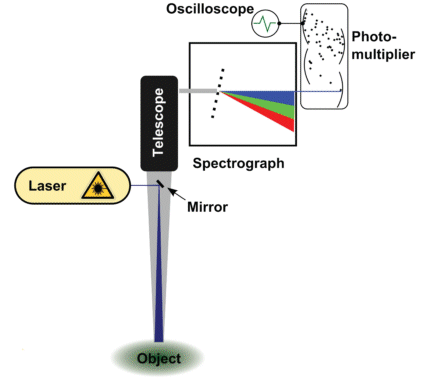
Being an active remote sensing method, lidar necessitates a light source that transmits visible light or radiation in the ultraviolet or infrared to the object being probed. This is achieved with a laser, capable of transmitting concentrated radiation over large distances. Because the objects of interest are usually in a very far location, a telescope is used to bundle an adequate amount of reflected light. This collected light is then broken down to its spectral components with the use of a spectrograph. A photo detector - mostly a photo multiplier - produces an electric output signal that can be processed with an oscilloscope or on a computer following analog-to-digital conversion.
Lidar can be used to investigate the composition of the atmosphere and oceans, and of the land surface. Besides the analysis of substances it is the distance to the object of interest which is simultaneously measured by the use of short laser pulses. Therefore, one can measure e.g. the topography of land surfaces or the height of clouds in the atmosphere; there are many applications, and some of them will be presented in detail in this tutorial.

