3. Syndromes of Global Change
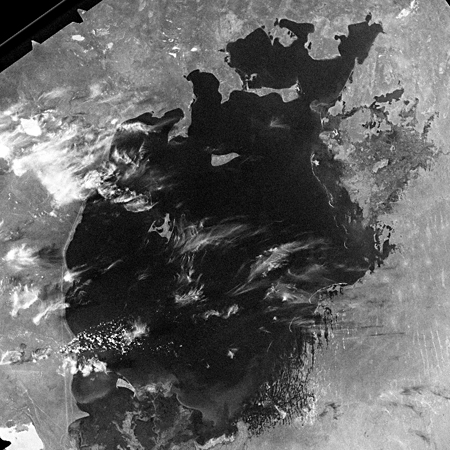
Aggradation of the Aral Sea
Until the 1960's, the Aral Sea was the fourth largest sea on the earth. Abutting nations are Kazakhstan and Uzbekistan. Because of massive irrigation, the Aral Sea has one of the largest man-created ecological catastrophe areas of the world, next to Chernobyl (NASA, Schlager 2000).
Agricultural Use
The people who lived in the cultivated land area are traditionally nomads and oasis inhabitants. The agriculture today still gives livelihood, despite the ever more drying climate. Water for the irrigation, which expands cotton-, vegetable-, wheat-, and rice fields, has been extracted mainly from both feeding streams of the Aral Sea Amudarja and Syrdarja. Industrial fishing also increased considerably. The main cause of the extreme water deficiency and the shrinking of the Aral Sea is very irrigation intensive cotton cultivation (Reuschenbach 2005, Schlager 2007).
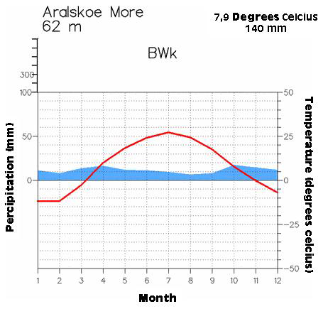
Source: Klimadiagramme.de
Consequences of Irrigation
In the path of canalisation and the connected interventions of the ecosystem of the Aral Sea, the water has been held back in artificial dams. Through this, the flow of water has been heavily reduced and the salinity has been raised, especially in the southern sea from until 50g/l (in comparison to: Atlantic Ocean: 35 g/l, Mediterranean 30 g/l, Dead Sea 330 g/l). The deterioration of the sea has happened, especially in the east, where the coasts run a level course. Consequently, the northern part of the Aral Sea has been detached from the remaining water body. The small island in the north western part of the sea has become a half island through the water level decline. Over the last 40 years, the Aral Sea, once the fourth largest lake in the world, has evaporated to half its original surface area and a quarter of its initial volume, leaving roughly a 36 000 square kilometre zone of dry white-coloured salt terrain now called the Aralkum Desert (Beckel 2007, ESA, Reuschenbach 2005).
With the continual deterioration of the sea, the climate in the region has also changed. Through less evaporation and less steam in the air, less condensation occurs. The climate will continue to become continental with short, hot summers and long, cold winters. The climate change has also had a negative effect on the regional condensation. Consequently, more sand storms occur, which displace per year more than 75 million tonnes of salt dust towards the north west. This dust releases not only enormous health damage with the population (Tuberculosis and Asthma), but it also makes massive usable areas unusable and drives to the salination of the ground water (Conrad 2002, Beckel 2007, ESA, Schlager 2007).
Tasks:
1. Describe the aggradation of the Aral Sea using the given satellite images and the Aggradation of the Aral Sea in fast motion.
2. Explain this aggradation. Use the following materials to explain: text, climate graph, thematic map.
3. Come up with a future concept for the region. How can it continue there?
Extra Material :
The aggradation of the Aral Sea in a Fast Motion Time Lapse
Thematic Map of the Region - Comparison of the Land use in 1960 and 2007