Mexico City has one of the world's most serious air pollution problems. The city is located atop a high plain at an altitude of 2,200 meters, and is surrounded on three sides by mountains and snow-capped volcanoes.
A flyby over Mexico City
For the display of this element you need a Flash-Player from Version 8 on.
Major sources of air pollutants within the basin enclosing the Mexico City urban area include exhaust from 3.5 million vehicles mostly running with unleaded petrol or sulphurous diesel. Thousands of industries, a fifth of Mexican industry, is located in the capital with partly outdated facilities, and mineral dust adds to the problem. The ancient lakebed valley in which Mexico City is situated was drained in the 16th century and became a major source of dust and dust storms, the so called Tolvaneros.
Each day 12 000 tonnes of toxic pollutants are emitted. In heights from over 2,200m the effects of UV-radiation are higher, while the amount of oxygen is reduced by 15%. Therefore the combustion process in automobiles and industry is therefore affected. High elevation and intense sunlight are key factors in ozone formation (Bauer et al. 2005, Claaßen 2008, NASA Visible Earth, Yip, Madl 2000).
Haze over Mexico City

Information about the satellite images ↓↑
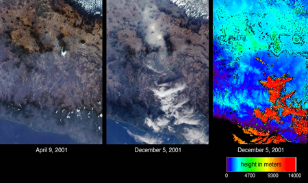
Atmospheric particulates (aerosols) and differences in their amounts on two days are indicated by the images of central Mexico from the Multi-angle Imaging SpectroRadiometer (MISR). The images on the left and in the center are natural color views acquired by MISR´s camera on April 9 and December 5, 2001, respectively. Mexico City can be identified in the center image by the large area of haze accumulation above the image center. Two small brighter patches within the hazy area indicate low fog. In the left-hand image, the city basin appears significantly clearer, but some haze remains apparent across the Sierra Madre mountains in the lower portion of the images. On the right is an elevation field corresponding to the December 5th view. This depiction reveals the clouds at the lower right to be at very high altitudes, in contrast to the low-lying haze and fog near Mexico City. When a location is not covered by clouds, digital terrain elevation data is displayed instead. High clouds appear as the orange and red areas, and mountainous areas appear light blue and green (NASA Visible Earth).
Health problems
The number of people with respiratory diseases and conjunctive inflammation is still increasing because of the air pollution problems in Mexico City (Bauer et al. 2005).
Environmental damage in Mexico City ↓↑
In the case of the Mexico City Metropolitan Area the major health impacts of air pollution originate from three major pollutants: suspended particulate matter, ozone (a secondary pollutant) and lead. It was estimated that some 11.2 million work-days would be saved each year by reducing pollution. 6 400 people a year are dying prematurely with an average of 12.5 years of life being lost because of pollution emissions which exceed legislative standards.
In regard to ozone pollution there are a number of other serious health problems including asthma attacks, eye irritation, mild cough, sore throat, headache and chest discomfort.
Lead is a particularly dangerous air pollutant. Nearly 95 percent of gasoline in the Mexico City Metropolitan Area, still contains lead. Relating to children a reduction in IQ is a result of lead poisoning. In adults, high levels of lead result in a number of health problems including high blood pressure and myocardial infarctions.
The water supply is another major environmental problem in Mexico City. Since the middle of the last century, underground water has been used, significant subsidence damage has been caused in the city itself with the ground level falling by eight metres or more in the historical part of the city.
The costs of these problems go into hundreds of millions of dollars (Margulis 1992).
Tasks:
1. Describe the topographic location and climatic situation of Mexico City with the help of the film and text.
2. Explain the satellite images and depiction of haze. What is the meaning of the light blue areas here?
3. Explain the environmental problems, referring to location, climate and the waste of resources.

