Remote Sensing of Natural Heritage Sites
Iguazu National Park (2/2)
Contribution of Remote Sensing:
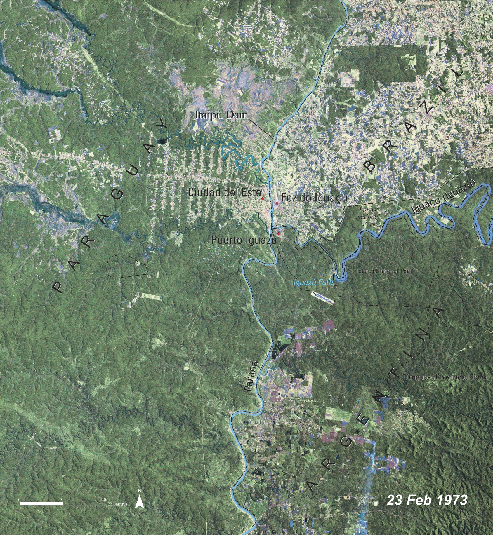
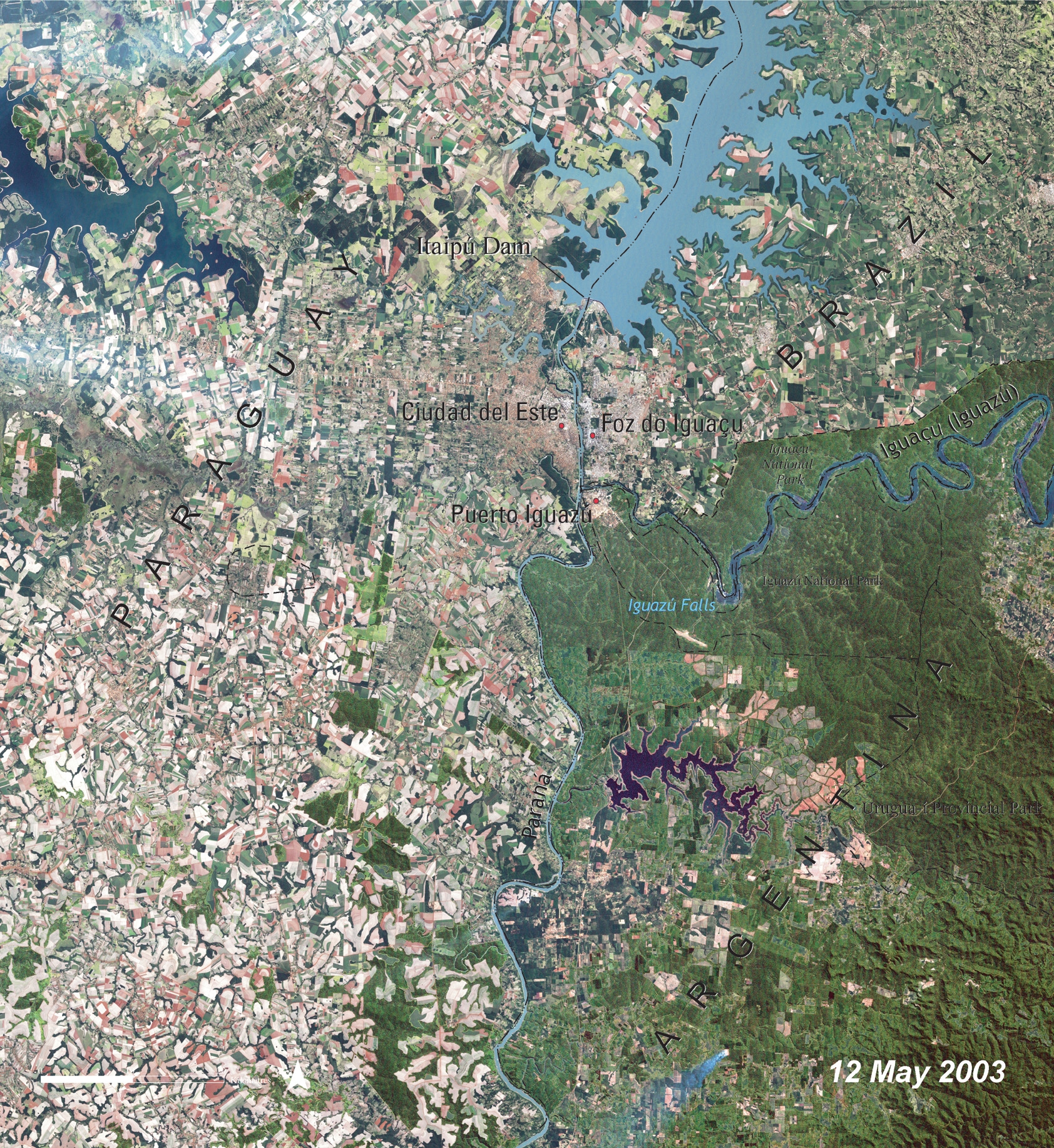
30 years of change in the World Heritage site of Iguazu
Conservation of natural heritage sites is closely linked to change that have taken place in this area. If there has not been any change in the site and its surroundings for a long time, the site is perfectly preserved and its internal evolution has been a natural one. Such a site requires almost no management since everything is managed by nature itself. However, if human activities have severely affected the site and/or its surroundings, management of the site is necessary and might become extremely complex.
Source: UNEP
Comparing the two satellite images of the Iguazu National Park area from 1973 (left) and 2003 (right) reveals that within 30 years large forest areas have been converted into agricultural fields, mainly in the left part of the image.
Agriculture arrives in 2003 exactly to the borders of the park. In addition, the Itaipu Dam was constructed between 1973 and 2003. It is marked in the upper right of the image (visible in the zoom).
The immediate surrounding area of Brazil (upper right), Argentina (bottom right), and Paraguay (left) was once native forest and grasslands, and both Argentina and Brazil have set aside land near the Falls as National Parks. The effect of differing land use policies can be clearly seen by comparing both images.
Paraguay has permitted complete development of the land belonging to its territory. In 1973, nearly the entire area west of the Parana River, (which runs vertically through the center of the image) was vegetated; in 2003, nearly all the land appears to be under human development, creating a patchwork of cleared and vegetated areas. In Brazil, a sharp line between solid vegetation and developed lands to the north marks the boundary of the Iguazu National Park.
Source: UNEP
This example illustrates a success story of the declaration of protected areas under the framework of the UNESCO World Heritage Convention using remote sensing data. Within the borders of the protected area agricultural activities are no longer allowed. It's interesting to note that in 1973, there were some cleared areas near the Iguazu River northeast of the falls. These areas were agricultural fields before the site was protected; once under protection, the agricultural patterns slowly disappeared while natural vegetation has been coming back. At the same time to the north, a huge lake has formed through construction of a dam in River Parana (Itapu dam), and the land around it has undergone large scale development.
In the Misiones Province of northeast Argentina, development is considerably more modest than Paraguay, though it too shows a new reservoir. To the northeast of the reservoir, patches of terraced-looking bare ground appear. This region of Argentina is home to some of the last remaining tracts of a tropical ecosystem called the Atlantic Forest, a tropical rainforest that once stretched along most of Brazil's Atlantic Coast and inland several hundred kilometers.
