Télédétection des sites du patrimoine culturel
Venise, Italie (2/2)
Contribution de la télédétection
De 2001 à 2003, le projet VENEZIA de l'ESA a été mené dans le but de mettre en place un service de surveillance de l'affaissement du sol dans la lagune de Venise à l'intention des autorités administratives régionales et des autorités chargées de la gestion de l'eau. Un élément important du projet réside dans l'intégration de techniques de surveillance par radar à synthèse d'ouverture (SAR) avec des levés de nivellement et GPS au sein d'une base de données et d'un système d'information globaux, capables de fournir les meilleures connaissances possibles sur le processus d'affaissement aux autorités chargées de la gestion de la plaine du Pô autour de la lagune de Venise.
Dans la lagune de Venise, les taux d'affaissement sont traditionnellement surveillés avec des fréquences temporelles et spatiales variables en fonction des réseaux de mesure au sol.
L'utilisation de mesures de tassement dérivées des données satellitaires permet d'améliorer la résolution spatiale et la fréquence temporelle à 25 m et au moins tous les 35 jours (orbites à passage répété dans le cas de l'ERS et de l'ASAR) pour les techniques DInSAR et IPTA. La combinaison des mesures au sol et satellitaires permet de confirmer la précision et de procéder à une validation croisée des mesures satellitaires, tout en fournissant des cartes améliorées et plus détaillées du tassement dans la lagune et ses environs.
L'image ci-dessous est une juxtaposition de données anciennes et récentes qui montre l'évolution de l'affaissement. Une photo aérienne ou satellite de Venise (en noir et blanc) est superposée aux données actuelles du satellite de reconnaissance terrestre (en couleur). Les données spatiales montrent qu’une partie de Venise s’enfonce millimètre par millimètre dans la mer – davantage dans les zones rouges et violettes que dans les zones bleues et vertes. Ces détails permettent de concentrer les mesures de protection structurelle aux endroits où elles sont le plus nécessaires.
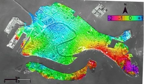
Source: GAMMA / ESA
Comme le montrent les figures relatives à deux zones spécifiques situées autour de la lagune de Venise, l’interférométrie SAR présente des caractéristiques complémentaires à celles des levés de nivellement, car elle permet de cartographier les zones urbaines avec une haute résolution spatiale. L’interférométrie SAR s’avère notamment très utile pour mener des études détaillées dans les zones côtières : à Chioggia et à Jesolo, on observe un gradient significatif de l’affaissement du sol vers la mer, pratiquement impossible à détecter par d’autres techniques de surveillance traditionnelles telles que le nivellement géométrique et le GPS différentiel. Une situation critique est également observée à Eraclea, où la vitesse d’affaissement atteint 4 mm/an. Les levés de nivellement de haute précision, quant à eux, sont utilisés en dehors des villes, comme à l’est de Chioggia, et pour établir un point de référence pour les valeurs d’affaissement mesurées par SAR. La grande précision des deux techniques de levé est confirmée par leur validation croisée le long des lignes de nivellement.


L'étude montre que la lagune centrale, qui englobe la ville de Venise, présente une stabilité générale, tandis que les extrémités nord et sud de la lagune, ainsi que leurs bassins versants respectifs, s'affaissent à des rythmes importants, avec une moyenne de 3 à 5 mm/an.
Les taux d’affaissement atteignent 10 à 15 mm/an sur le littoral situé au sud de la lagune. Des soulèvements relativement faibles (moins de 1 mm/an) sont observés dans les contreforts des Alpes et dans une vaste zone comprise entre les collines euganéennes et la lagune.
Les déplacements du sol observés ont été associés aux caractéristiques géologiques de la région étudiée, à savoir la tectonique, la sismicité, la consolidation différentielle des dépôts du Pléistocène moyen-supérieur et de l’Holocène, ainsi qu’aux activités anthropiques, telles que la remise en état des terres et le prélèvement d’eau souterraine.
Les résultats du projet démontrent que cette intégration dans la compréhension du processus d'affaissement peut être efficacement mise en œuvre tant pour une analyse rétrospective de la dernière décennie que pour le suivi futur des tendances évolutives. La collecte de ces caractéristiques physiques de l'environnement est actuellement indispensable aux travaux de restauration urgents et aux plans de conservation de l'écosystème de la lagune. À l'avenir, la connaissance de l'affaissement du sol pourrait faciliter l'exploitation potentielle des ressources souterraines, à savoir l'eau dans les zones côtières et les bassins versants, ainsi que le gaz au large du littoral.
Source: GeoEye 2009
