3. GPS Applications
Georeferencing or Geocoding (1/2)
During a flyover, images of the Earth's surface can be taken with the use of a scanner attached to an aircraft. Such images are often blurred or distorted because it is quite impossible for the aircraft to fly a perfect straight line due to certain factors like wind, for instance.

In addition to wind, there are other factors that may contribute to image distortions, such as the movements of the aircraft itself (like lurching or tilting), the surface structure of the terrain being scanned, as well as the quality of the technical equipment being used. This application deals with the geometrical adjustments to correct said distortions.
The measuring system used for taking images is composed of a GPS-antenna with an appropriate receiver, and a measuring unit for determining the position or bearing of the aircraft (from lurching or tilting).
The image to be corrected is taken with the Sensor AISA Eagle, a scanner used for taking images under different wavelengths in the visible light spectrum.
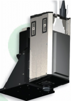
The AISA Eagle takes images having wavelengths of 400 to 970 nm. The spectral resolution of each image is 2,9 nm. The sensor is equipped with a total of 286 channels, therefore, it can record 286 images under different wavelengths. Other features of the sensor are: mass 11 kg, length 380 mm, width 220 mm, height 550 mm. A GPS-device is mounted on top of the sensor. The sensor itself is mounted on the motor glider Condor.
