Fly Over
Have you ever been to New York to see the wonderful Brooklyn Bridge or the Empire State Building?
Not everyone has the chance and the means (especially poor students!) to buy a ticket to the Big Apple and visit all that beauty.
There is a temporary solution for this problem! It's called Google Earth. Most of you have already heard of this wonderful website, where the whole world can be seen from space. And the application gets more sophisticated with every new version! It is even possible to see 3D on your computer screen!
If we can't go to New York, let's bring New York to us!
Objectives
- You will explain the meaning of the word ‘fly over’.
- You will work with several 3D tools in Google Earth.
Materials
- Worksheet ‘Fly over’
- Internet access
Preparation
- Download Google Earth at http://earth.google.com/ (the latest version)
- The starter page is an image of the Earth seen from space.
- To get used to the program of Google Earth, you can try the following applications:
- Find the city where your school is located using the ‘zoom in’-button in the right corner.
- Let the computer find the same place automatically (Tip: ‘Fly to’).
- Do you find an application to find the shortest path from one place to another? Try it with an example in your neighborhood.
Exercise
Zoom in on New York City.
- New York is divided into five zones, called boroughs.
Name the five boroughs and shade them in the satellite image.
Tip: You can use the internet!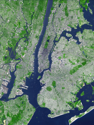 New York City. Source: NASA, 2002
- Which important buildings or places in New York are being referred to here?
- Highest building?
- The most famous park?
- A complex of 14 commercial buildings, where an ice-skating rink and large Christmas tree are located during winter?
- World famous street intersection, with a lot of electronic billboards? The Broadway theatres are also located here.
- It takes some time to update all satellite images used in Google Earth. Are the satellite images taken
before or after 2001?
Is there a particular feature on the image that can justify your conclusion?
- The images you see in Google Earth, are they 2D or 3D?
Let's add a third dimension!
In the left column, there is an area where different layers can be activated. Activate the layer ‘3D-buildings’. As the name of the layer implies, all buildings that are taller than a certain height are depicted in 3D!
Look at Brooklyn Bridge in its three dimensions: length, width and height.
Tip: you can navigate (up, down, to the left to the right, from a different angle) with the buttons in the right corner.
Task: Calculate a route from Brooklyn Bridge to the Empire State building. Click ‘Start Tour’. Now you see a fly over tour of New York along the path you constructed.
Note: You can change the settings (angle of the camera, reach of the camera) as follows: Extra ⇒ Options ⇒ Route.
