5. Urban Planning
Urban land cover changes
Question: Which are the most usual changes in an urban area?
Here, are some examples of temporal urban land cover changes:
Source: Federation of American Scientists
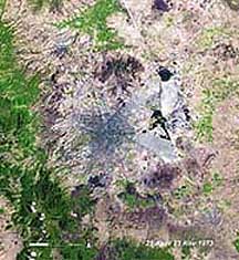
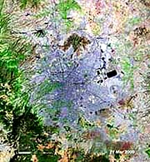
Mexico City has been forecasted to enlarge to well above 20 million people by the mid-21st century (by then Tokyo will have gone above 30 million as the most populated urban area on Earth). Here is Mexico City in two satellite images, the left (or top) one taken in 1973 (population then at 9 million) and the right in 2000 (14+ million).


Source: NASA
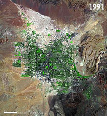
In 1973, Las Vegas had about 358,000 residents; by 1992 the city had grown to more than 937,000. Growth of the city is evident in comparing a 1973 Landsat subscene to one acquired in 1992. At the end of 2000, Las Vegas was now a megacity of 1,563,000 citizens: Below at left, is a Landsat TM view. Growth continued unabated through 2006, when the population topped 2,013,000. The city has been spreading south and east. But water availability problems have now slowed growth.
Which is the role of remote sensing in monitoring changes in an urban area?
The advent of satellite imagery has created new sources of information for those involved in urban management. With sensors such as the SPOT panchromatic system (10m resolution) and the Indian IRS (5.8m resolution), mapping is already possible at the 1 : 50,000 - 1 : 25,000 scales. The IKONOS satellite provides 1m resolution images which make mapping at the 1:10,000 scale feasible. With tools such as these, it will be possible to monitor urban land use changes throughout the world with increasing accuracy over the next 10-20 years.
Remote sensing can provide synoptic views with high detail and high temporal frequency. Despite the developments, conventional aerial photography is likely to remain the primary source of remotely sensed information for the foreseeable future at the land parcel level (i.e., 1:2500 - 1:500 scales) which is the basic building block of the data bases used by those involved in urban planning and land administration. In order to have more accurate results it is important to use applications of remote sensing in combination with other methods such as spatial metrics.
Combining additional tools with remote sensing for urban change detection
The combined and integrated application of remote sensing, spatial metrics, and urban growth models represents urban growth patterns. Such an approach can be used to supplement the available tools for urban planning. Considering the availability of historical data sources (air photos) and data from new high-resolution sensor systems like IKONOS, the combined approach has demonstrated the capabilities for improving the knowledge, understanding, and modeling of urban dynamics.
Quantify and monitor changes in urban land covers
As the world's cities continue to grow in both population and physical size, greater consideration of the manner in which rural lands are developed for urban and suburban land use will become progressively more important. Planners are increasingly pressured with the challenge of balancing the demands for urban and suburban growth while mitigating the negative environmental impacts of development. Removal of rural land cover types such as soil, water, and vegetation and their replacement with common urban materials such as asphalt, concrete, and metal have significant environmental implications including reduction in evapotranspiration, promotion of more rapid surface runoff, increased storage and transfer of sensible heat, and reduction of air and water quality. These changes, in turn, can have negative effects on landscape aesthetics, energy efficiency, human health, and quality of living in urban environments Among the most widely studied consequences of converting rural land cover to urban and suburban development is the urban heat island (UHI), which is manifested by higher surface and air temperatures within urban environments as compared to surrounding rural areas.
Contemporary urban growth will also have socio-economic impact. Cities have always exerted a disproportionate social, political, and economic influence on the areas surrounding them and on the regions and nations of which they are a part.
Rapid urban growth means that most cities are in a constant state of transition. Consequently, monitoring and evaluating urban change is a major issue in urban planning and management throughout the third world. Key research topics within this general theme are the use of remote sensing and related technologies to map changes both around the urban-rural fringe and also within the built up area itself. Other research topics of some importance from he standpoint of current planning practice are the construction of various types of urban indicator from conventional and remotely sensed information to facilitate national and cross national comparisons of urban regions.
Nevertheless it must be borne in mind that, despite these developments, conventional aerial photography is likely to remain the primary source of remotely sensed information for the foreseeable future at the land parcel level (i.e., 1 : 2500-1 : 500 scales) which is the basic building block of the data bases used by those involved in urban planning and land administration. With this in mind it is also worth noting that recent developments in aerial photography have substantially increased its potential usefulness for these purposes. These include improvements in film quality, better quality lenses and the use of GPS for positioning purposes. The forthcoming arrival of the digital survey camera will also provide direct images that are compatible with a digital geoinformation production line.
As land use change models incorporate both human and natural systems, the requirements placed on the data are fairly complex, ranging from environmental and ecological parameters to socioeconomic information, and detailed land use and land cover data with known spatial and temporal accuracy . Important data sources are the decennial census or other housing data that are routinely collected by governments, and by planning agencies. However, there are problems associated with spatial social data; they do not have a uniform global availability - they are frequently unavailable for developing nations; spatial social data may be classified or available only through private or restricted government sources; they can have poor temporal accuracy and consistency, and they often contain the wrong thematic representations for objective urban analysis.
