5. Urban Planning
Urban thematic mapping through remote sensing
Remote sensing can provide synoptic views with high detail and high temporal frequency. Remote sensing products can be used to map major urban features, land cover types, detailed land use or urban infrastructure, from which can be derived secondary socioeconomic parameters and the invisible elements of urban infrastructure. Remote sensing also contributes to a better representation of the spatial heterogeneity of cities, a counter tendency to the limitations of models that tend to reduce geographic space to the single dimension of distance, thereby hiding important spatial patterns in land use and landscape features.
Objects in an urban area can be distinguished according to their:
- shape
- size
- texture
- orientation
- pattern
- shadow
Distinguishing urban from non-urban areas using remote sensing
A difficulty in using remote sensing technology for urban studies is the diversity of features found in the urban environment, including different targets like concrete, asphalt streets and avenues, roofs of different materials, exposed soil, grass, trees, and water. Some of these targets are smaller than the pixel resolution. Although there are significant differences between the spectral reflectance of urban surfaces and natural rock and soil surfaces, these differences may be difficult to detect with the limited spectral resolution provided by broadband sensors such as Landsat TM.
This distinction depends on both the aggregate and component physical properties of the urban mosaic as well as those of the surrounding non-urban land cover types. The task is complicated by the fact that some of the components of the urban mosaic (e.g.vegetation, water) are also found in non-urban areas.
The task is further complicated by the fact that the spatial scales of the individual components in the urban mosaic (e.g. buildings, streets) is generally comparable to the spatial scale of the Ground Instantaneous Field Of View (GIFOV) of the sensors used to map urban extent (e.g. Landsat, SPOT). The task is still further complicated by the inter-urban and intra-urban diversity of land covers and their physical properties.
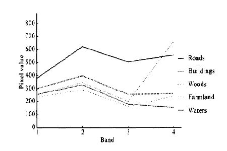
Source: Kong et. al., 2006, Classification and Extraction of Urban Land-Use Information from High-Resolution Image Based on Object Multi-features, Journal of China University of Geosciences, vol. 17, issue 2, p. 151-157.
The figure above shows that it is very difficult to classify and extract urban land-use information based on spectral features only, and the accuracy of the extraction result is not high.
