3. Sustainable Forest Management
Forest Fires
Forest fires are a big threat to the forests of our planet. During the summer, the hot temperatures along with the increased winds, help in the fast spreading of a fire. And most of the times, it is human activity that causes the fire in the first place.

Source: NASA Earth Observatory
On the image above, captured by the MODIS sensor onboard NASA's Aqua satellite, we can see a series of fires along the north coast of Algeria in North Africa, during the summer of 2007. The smoke is being carried towards the north-east and spread over the majority of the Mediterranean sea (click on the image to see a larger version).
Some satellties have a high enough temporal resolution, that allows the coverage of the same area more than once a day. These satellites are very useful for monitoring fast developing events, such as forest fires.
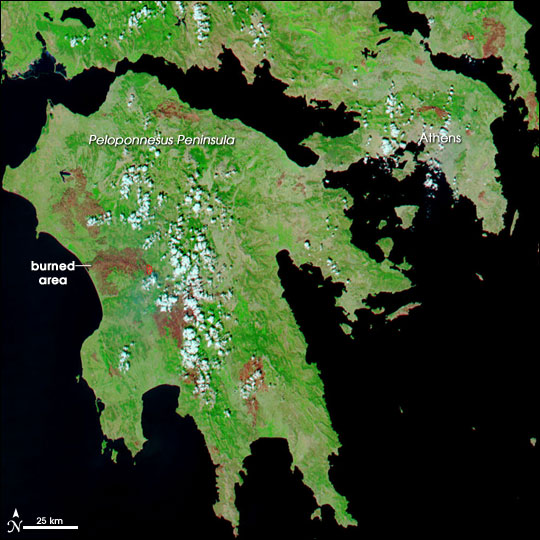
On the image on the top-right, we can see a satellite image of the Peloponnese area of Southern Greece. Fires wiped out large forested areas in the region, in August 2007. In this case, the winds are carrying the smoke towards the south-west, over the Mediterranean Sea and North Africa.
The image on the bottom-right, is a classification of a satellite image. Because the areas that are burnt from fire have a very distinctive spectral signature, it is easy to identify those areas with the classification of a satellite image. The magnitude of the destruction is a lot more obvious when the smoke plumes are not present to cover the scene.
Forest fires can be identified from the presence of smoke (remember the saying: where there's smoke, there's fire), but also from the high temperatures that are developing during a fire. Remote sensors sensitive in the thermal infrared region of the spectrum, can identify locations with a higher temperature than the surroundings.

Source: NASA Earth Observatory
Source: NASA Earth Observatory
